Andes and Himalaya
Glacial Processes in the Peruvian Andes and the Nepalese Himalaya, and Implications for Glacier Hazards
Hambrey, Michael, Neil Glasser, Bryn Hubbard, Richard Lucas, Sam Clemmens and Duncan Quincey.
Glaciers around the world are receding from their most recent maximum positions attained between 100 and 300 years ago. One consequence of this recession is an unexpected increase in the threat they pose to human habitation, especially in high mountain regions at low latitudes. The main hazards that are now developing are ice avalanches and failure of glacial lakes. One area in particular, the Cordillera Blanca in Peru, has suffered more than any other. In the 20th century, as many as 32,000 people may have died from glacier-related disasters. Other areas, such as the Himalaya, Hindu Kush and Pamir regions of Southwest Asia, the Caucasus Mountains, ranges of Northwest America and the Alps have also seen the loss of hundreds of lives and severe damage to infrastructure. Recently the Organisation for Economic Co-operation and Development (OECD) published a report on the negative effects of climatic change, and highlighted outbursts from glacial lakes as a growing problem.
The failure of moraine-dammed lakes such as this (Ahueycocha, Cordillera Blanca) have caused huge loss of life in the past century. Identification of the hazardous lake and their remediation is therefore of paramount importance. Photo: M. J. Hambrey.
When a high mountain glacier recedes, a lake commonly develops between it and a ridge of loose debris (a terminal moraine) pushed up in front of the glacier at its maximum position. The moraine in effect is an unstable dam that often has a core of decaying buried ice. As the lake grows larger, the moraine dam can fail, and the consequences of the resulting flood of many million cubic metres of water can be extremely devastating. More and more moraine-dammed lakes are forming in both populated and remote areas, and the challenge is to identify and remediate these before they reach a critical state of instability. Much as ground observations are vital, many areas are too remote or difficult to reach for scientists with limited time. For this reason, new techniques including remote sensing are needed to evaluate hazards in high mountain regions.
In a unique partnership under the UK Government's TCS programme, the Centre for Glaciology at the University of Wales, Aberystwyth has joined forces with the world's leading glacier hazard company Reynolds Geo-Sciences (RGSL) of Mold, North Wales. Our collaborators are Dr John Reynolds (Managing Director), Dr Shaun Richardson (glacial geologist) and Mr Andrew Heald (geotechnics; land stability). Together, we are investigating glacier hazards in the Cordillera Blanca of Peru and the Mount Everest region of Nepal. The work involves field-based investigations such as mapping of landforms and surface features, documenting sediments associated with moraine-dams and measuring key attributes (e.g. roughness) of the ground, both on and surrounding several glaciers. This work has provided valuable data for developing more effective techniques for assessing glacial hazards from aerial photography and imagery acquired by satellite sensors such as Landsat, SPOT and ASTER. We have also used a combination of field and remotely sensed data to generate three-dimensional perspectives of glaciers and calculate changes in the volume of ice and moraine through time. So, indirectly we are also able to investigate the response of glaciers to recent climatic change in regions where few data are available.
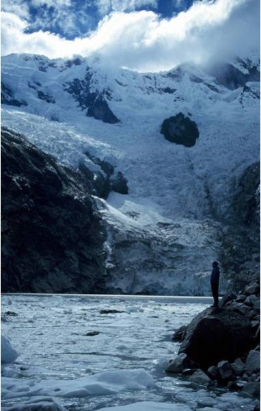
The moraine-dammed lake at Safuna. A large-landslide in 2002 fell into the far side of the lake, covering the glacier terminus and creating a wave over 100 metres high. The light-coloured areas of the moraine show where the wave splashed over the moraine and partly eroded it. The lake level is low because tunnels were excavated through the moraine to reduce the potential for breaching. Nevertheless the rockfall-generated wave almost resulted in failure. Photo: B. Hubbard.
The first phase of our work (July/August 2002) took us to the Cordillera Blanca for a collaborative programme of research with the Peruvian government organisation responsible for mountain hazards, the Instituto Nacional de Recursos Naturales (INRENA). We concentrated initially on Laguna Safuna, a lake impounded by a terminal moraine. It became evident that a massive landslide had, only months earlier, displaced a wave of water that had overtopped the moraine dam and caused considerable erosion to both its flanks. Thankfully, the moraine dam was not ruptured by this 90 m-high wave, and no large-scale flooding resulted from the event. We evaluated the magnitude of this event and establishing the likelihood of a similar event occurring in the near future. We are continuing this work in collaboration with colleagues at INRENA.
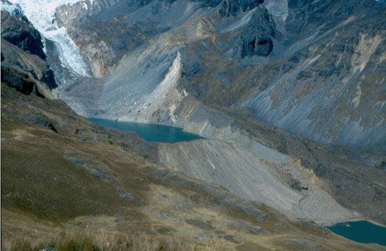
Detailed mapping and sediment analysis was also undertaken at two other sites in Peru. At Raucolta, analysis of satellite sensor data indicated the possibility of a hazard developing over the next decade, but on the ground no significant lake development was evident because of free drainage through the sandy and bouldery moraine dam. In contrast, at Ahueycocha, a moraine dam holds back a 1.5 kilometre-long lake, formed within the last 30 years. Although Peruvian engineers have undertaken remediation measures, the site is not entirely secure, because a large ice avalanche or rockfall may generate a wave that could breach the dam.
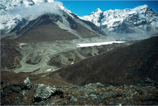
In the spring of 2003, the team undertook a joint programme in the Mount Everest region of Nepal, where glaciers are in various stages of decay, and some glacial lakes have already burst. Supported by Sherpas, porters and yaks, we first worked on the debris-covered tongue of the Khumbu Glacier at around 5000 m, the famous southern highway to the foot of Everest. Next Imja Glacier was examined, together with its well-developed moraine-dammed lake and the surrounding area. At both sites, sediments and landforms were mapped, and data gathered to facilitate interpretation of the remote sensing data.
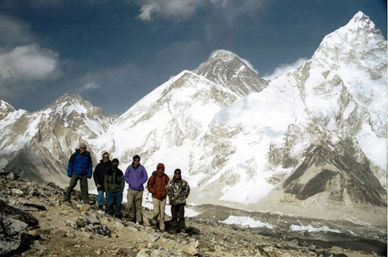
The field party with Sherpa guides above the Khumbu Glacier, with Mount Everest in the background and Nuptse to the right. Photo: D. Quincey.
Using a variety of remote sensing techniques, we are now investigating the level of information that can be derived from the spatial and spectral characteristics of glaciers and their surrounding environments, which are not normally available from ground-based investigations. Early results show that the characterisation of the dominant rock types on the glacier surface is possible, as well as the detection of surface ponding. On the other hand, automatic classification of the extent of debris-covered glaciers is more challenging as the surface debris gives the same spectral response as the moraines.
Imja Tsho with its wide, complex moraine dam. The debris-covered Imja Glacier is at the far right, beyond the frozen surface of the lake. Nepal. Photo: M. J. Hambrey.
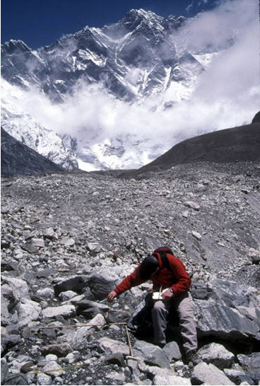
Measuring surface roughness on Lhotse Glacier for calibration with remote sensing data. Photo: Shaun Richardson
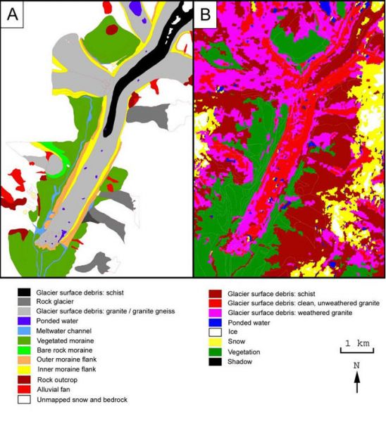
Khumbu Glacier, Nepal, showing a comparison between (A) a gemorphological map based on field mapping and SPOT satellite imagery, and (B) a spectral analysis of ASTER imagery supported by field observations. This represents the first step in providing data to underpin an assessment of glacial hazards. Satellite image proocessing: D. Quincey
We are also using the delineation of water bodies from satellite sensor data to track the development of hazardous glacial lakes through time, as well as reconstruct past scenarios. Using 3-D digital models we are making comparisons with aerial photography to determine the extent to which the integration of remote sensing data can be used to complement field data, particularly for mapping purposes. We are not only able to analyse volume changes of glaciers, but also identify areas vulnerable to avalanche and landslide events. Most recently, we have been investigating the use of Synthetic Aperture Radar (SAR) to identify geometrically stagnant glaciers (which promotes lake development), with a view to mapping hazard potential on a catchment scale.
The spin-off from our joint venture is considerable. For RGSL remote sensing expertise is becoming embedded within the company, and gives it scope for offering an enhanced service in glacier hazard management. For the University of Wales it has resulted in several significant developments in our understanding of glacial processes in high mountain regions, and on remote-sensing based applications to glaciology, as well as a better understanding of the response of glaciers to climatic change.