Patagonia
The Patagonian Icefields: Landforms, Sediments and Glacier Fluctuations
Glasser, Neil, Michael J. Hambrey and Krister Jansson
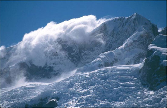
Spindrift shrouds the upper reaches of Cerro Hyades (3042 m), North Patagonian Icefield, Chile.
Photo: M. J. Hambrey.
The Patagonian Icefields
There are two main icefields in Patagonia, straddling the Andes on the border between Chile and Argentina. They represent one of the most important regions in the Southern Hemisphere for monitoring the response of ice masses to climatic change.
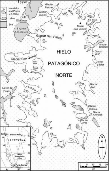
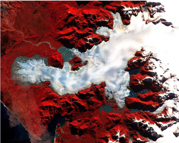
- The Northern Icefield (Campos de Hielo Norte or Hielo Patagonico Norte in Spanish) extends for near 200 km and covers a surface of 4,200 km2 (Figure 1). Ice thickness reaches 1,400 m.
- The Southern Icefield (Campos de Hielo Sur or Hielo Patagonico Sur) is even bigger, with a surface of around 13,000 km2. It is over 350 km long, with an average width of 40 km and ice thickness are also greater than 1,000 m.
Both icefields are located along the Andes at an average altitude of 1,500m. Some forty outlet glaciers discharge from the North Patagonian Icefield, and sixty from the Southern Icefield. The Northern Icefield is entirely located in Chile, and includes the famous San Rafael Glacier, which is the nearest tidewater glacier to the equator in the world. Although located mainly in Chile, some outlet glaciers of the Southern Icefield also extend into Argentina, such as those of the Los Glaciares National Park.
Annual precipitation on the western side of the icefields increases from 3,700 mm at sea level to an estimated maximum of 6,700 mm at 700 m above sea level on the icefield summits. Precipitation then decreases sharply on the eastern side of the icefields, although few data are available and this statement is based on the increasingly xeric nature of the vegetation.
The North Patagonian Icefield
Both icefields are nourished by the mid-latitude weather systems and are characterised by abundant precipitation, high ablation rates, steep mass-balance gradients and high ice velocities. Some of the glaciers terminate on land, whilst others end in lakes or in the sea, where they form calving fronts.
Research by Centre for Glaciology staff in Patagonia
Two members of the Centre for Glaciology have undertaken fieldwork in Patagonia. Dr Neil Glasser has spent three field seasons working on and around the icefield and Prof. Mike Hambrey has spent one season there. Another member of the Centre for Glaciology, Dr Krister Jansson, is currently working on satellite-image interpretation of the geomorphology of the area surrounding the North Patagonian Icefield.
The research in Patagonia falls broadly into two categories:
- Glacier structure, debris entrainment, transport and deposition
Most of our research in this area has been conducted in the proglacial area of Soler Glacier, one of the major outlet glaciers of the North Patagonian Icefield.
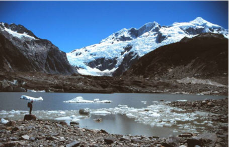
Soler Glacier, an outlet glacier from the eastern side of the North Patagonian Icefield. The glacier is fed from the icefall at the top of the image. The snout of Soler Glacier is currently receding into the proglacial lake in the foreground. Photo: M. J. Hambrey.Field investigations carried out there in January 2000 showed that the dominant structures in the glacier are ogives, crevasses and crevasse traces. Thrusts and recumbent folds are developed where the glacier encounters a reverse slope, elevating basal and englacial material to the ice surface. Other debris sources for the glacier include avalanche and rockfall material, some of which is ingested in marginal crevasses. Debris incorporated within the ice, and on its surface, controls both the distribution of sedimentary types on the forefield and moraine-ridge morphology. Sediments in moraine ridges on the glacier forefield include large isolated boulders, diamictons, gravel, sand and fine-grained facies. In relative abundance terms, the dominant sediments and their interpretation are sandy boulder-gravel (ice-marginal), sandy gravel (glaciofluvial), angular gravel (supraglacial) and diamicton (basal glacial). Proglacial water bodies are currently developing between the receding glacier and its frontal and lateral moraines. The presence of folded sand and laminites in moraine ridges in front of the glacier suggest that during a previous advance, Soler Glacier over-rode a former proglacial lake, reworking lacustrine deposits. Post-depositional modification of the landform/sediment assemblage includes melting of the ice-core beneath the sediment cover, the redistribution of finer material across the proglacial area by aeolian processes, and fluvial reworking. Overall, the preservation potential of this landform/sediment assemblage is high on the centennial to millennial timescale.
- Holocene glacier fluctuations and palaeoclimate
This is a new research area, which aims to establish the age of the pre-"Little Ice Age" moraine systems in front of the glaciers draining the North Patagonian Icefield. The work is in collaboration with Dr Stephan Harrison (University of Oxford), Professor Masamu Aniya (University of Tsukuba, Japan), Dr Susan Ivy-Ochs (ETH Zurich, Switzerland), Dr Geoff Duller (Quaternary Environmental Change Research Group, Aberystwyth), and Andres Rivera (University of Bristol). The comparison of outlet glacier behaviour across the icefield will provide insight into the climatic controls on glacier behaviour, including the critical role of the South Westerlies and the Southern Oscillation ("El Niño") in the climate system. Over human timescales, the major control on global sea level at present is the volume of water stored in glacier ice and snow. As glacier ice builds up on land, fresh water is stored in ice, and as glaciers recede this water is released to the oceans. A key question is therefore the rate at which Earth's glaciers are receding and their potential contribution to global sea level.
The age of the pre-"Little Ice Age" moraine systems will be established using geomorphological mapping, tied to cosmogenic isotope analysis and optically stimulated luminescence dating methods. During the austral summer of 2002/2003 we visited two of the valleys occupied by major outlet glaciers on the east side of the North Patagonian Icefield (the Leones and Exploradores Valleys) in order to undertake detailed field, sediment description and sample collection. Operation Raleigh provided logistical support for the project. The field data collected included:
- Geomorphological maps of the landforms created during glacier recession in the two valleys
- Detailed maps and topographic profiles illustrating the sediment/landform associations in the two valleys
- Descriptions of the sedimentary facies in the moraines and associated glacigenic landforms
- Collection of a number of samples of dateable material, including granitic boulders from the surface of moraines (for dating by cosmogenic isotope analysis) and samples of glaciofluvial material (for dating by optically stimulated luminescence). Dates will be available upon completion of laboratory analysis.
This is the first time that these new dating techniques have been used to identify periods of glacier expansion and contraction in this region. The data collected will be used in future scientific publications concerning the timing and extent of fluctuations of the glaciers of the Icefield. The team also intends to make a return visit to the western part of the North Patagonian Icefield in 2004 to undertake a comparative study of the glaciers on the other side of the icefield.
ASTER image of Glacier San Quintin, an outlet glacier on the west side of the North Patagonian Icefield. A large arcuate moraine in front of the glacier marks its maximum Twentieth Century limit. The glacier is currently receding into a proglacial lake. We have mapped the geomorphology of all the outlet glaciers of the icefield using images such as this. Image courtesy of the U.S. Geological Survey.A Holocene chronology has also been determined for the proglacial area of Soler Glacier, described above. The glacier is currently receding from its Little Ice Age maximum position, attained sometime between AD 1600 and 1900. Across the snout and forefield of the glacier is an arcuate belt of well-sorted granule gravel and coarse sand containing tree remains. These sediments are interpreted as reworked glaciolacustrine material, elevated to the glacier surface by thrusting and folding. Radiocarbon dating of samples of tree remains in these reworked glaciolacustrine sediments demonstrates that the glacier overrode this lake bed sometime between AD 904 and AD 1334. In situ tree remains plastered onto a large boulder in front of the glacier constrain this advance to the period between AD 1222 and AD 1342. This advance precedes by several hundred years the maximum Little Ice Age extent of other North Patagonian Icefield outlet glaciers, suggesting either an early age for the onset of Little Ice Age conditions or a previously unrecognized period of glacier advance. Prior to the advance at c. AD 1222 to AD 1342, Soler Glacier was more recessed than at present, confirming the dynamic response of Patagonian glaciers to Holocene climatic fluctuations.
The research in Patagonia has been funded by grants from the UK Natural Environment Research Council, the Royal Geographical Society and the University of Wales. Krister Jansson's contribution to this project was funded by the Royal Physiographic Society, Lund, Sweden. We also thank Raleigh International for field logistical support in Chile over a number of years.
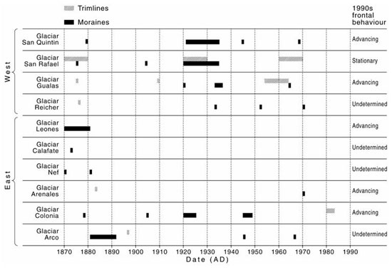
Late Holocene ("Little Ice Age") and recent fluctuation history of ten outlet glaciers of the North Patagonian Icefield reconstructed using dendrochronology and lichenometry.
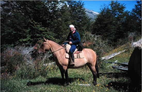
Glaciology on horseback. The route to Soler Glacier in the North Patagonian Icefield included a 30 km journey through southern beech forest, across mountain spurs and crossing several glacial rivers. Photo: Neil Glasser.