SEVIRI PrePro: A Novel Software Tool for the Pre-processing of SEVIRI Geostationary Orbit EO Data Products

Background
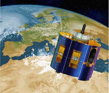 The Spinning Enhanced Visible and Infrared Imager (SEVIRI) is a geostationary orbit imaging radiometer which serves as the main payload on-board the Meteosat Second Generation (MSG) satellite. This is a co-funded space mission between the European Space Agency (ESA) and EUMETSAT. SEVIRI has 12 spectral channels, consisting of three Visible and Near-InfraRed (VNIR) channels (centred at 0.6, 0.8 and 1.6 μm), eight InfraRed (IR) channels (centred at 3.9, 6.2, 7.3, 8.7, 9.7, 10.8, 12.0 and 13.4 μm) and one visible broadband channel (at 0.5–0.9 μm) called the High Resolution Visible channel (HRV). The satellite provides image data at 3 km spatial resolution at the sub-satellite point (nadir) for standard channels, and down to 1 km for the HRV channel, over 4 specific geographical regions (Europe, Africa - North_Africa and South_Africa- and South America), with a baseline repeat cycle of 15 minutes. A series of operational products from SEVIRI are provided by EUMETSAT and distributed by the Satellite Application Facility (SAF) on Land Surface Analysis (LSA) (http://landsaf.meteo.pt/).
Here we present an open source stand-alone software tool, developed in Java, which allows performing basic, yet of key importance, pre-processing steps to the SEVIRI operationally distributed products. The software platform, named “SEVIRI PrePro”, makes also use of present day multi-core processors, being able to process fast very large datasets, making it also suitable for use in a High Performance Computing (HPC) environment. Furthermore, we demonstrate the practical applicability of this tool using as an example an operationally distributed product from SEVIRI, although equally any other operational product may be used.
SEVIRI Pre-Pro Description
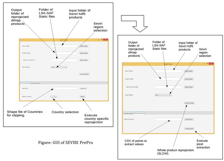
The tool has been developed in Java, as a stand-alone application with or without GUI and also as an add-on in BEAM VISAT open access image processing platform. Figure 2 describes the workflow and the options a user has in using SEVIRI Toolbox. Capabilities of the toolbox include: reprojection, clip and extract pixel values from SEVIRI images (either raw images or any operational product). Figure 3 presents the GUI for SEVIRI Toolbox implementation.
To execute SEVIRI PrePro, first the static HDF5 files for the region of interest need to be downloaded, which are provided by LSA-SAF, subject to registration to their site. Once this step is completed, the user will need to authorise their account before they can request the necessary static files. Using this authorisation the user can download the necessary files located in the “Auxiliary Data” tab. On the website is a list of .bz2 files in .HDF5 format. The user is advised to download all available files and store them in a folder since it can be used for further reference. The structure of the folder is illustrated in Figure 1. After the .HDF5 data have been acquired, Java 8 needs to be installed to take advantage of speed and Graphical User Interface (GUI) available through Java FX improvements. The installation has been tested with the corresponding JDK (at time of writing JDK 8u60 was the most up to date version and used in implementation).
A short description of the interface is presented below:
Step 1: Select the folders containing SEVIRI (HDF5) images and the folder where the reprojected results are stored. All the output images are stored in BEAM DIMAP format.
Step 2: The user must select a folder containing static LSA-SAF (available to registered users) co-ordinate transformation files. These are used to translate to WGS84. These are provided for four regions. The user must select the relevant one.
Step 3: There is an option to subset the SEVIRI product or use all of it (a very slow process). If clipping is selected this can be done by using a shapefile (.shp) containing countries. The user can select the relevant country.
Step 4: There is an option to extract pixel values by point (e.g. in case where coordinates of a location are known to user)
Innovation & Impact
 SEVIRI PrePro is able to perform simple yet of key importance pre-processing steps which make the use of SEVIRI data products much easier to use than ever before in many practical applications and research purposes alike. The toolkit, which is also made available open access and with complete documentation, makes use of present day multicore processors. The latter allows processing very fast datasets of any size using personal computers, whereas it is also suitable for use in a High Performance Computing (HPC) environment. From an algorithmic and software development perspective, a further important advantage is the tools’ ability for inclusion of key functionalities such as shapefile incorporation for points or areas extraction. Its application also allows for the analysis of a single or multiple operational products, producing robustly accurate long time series analysis data, yet requiring much less effort and user expertise in comparison to more other approaches (e.g. by a Matlab routine). Finally, SEVIRI PrePro is robust and fully adaptable to be potentially integrated with other EO data, and, as it is realised under GPL v3, anybody can contribute changes or suggest features, which consists a further advantage of the tool.
To our knowledge, there is no other similar kind of open access software platform available at present to support the pre-processing of SEVIRI operational products for either research or educational purposes. Thus, this toolkit distribution is also very timely and it is anticipated to make a significant contribution to a large number of practical applications requiring use of SEVIRI data products, allowing a wider dissemination of those data to prospective users.
Publications/Dissemination
- Petropoulos, G.P. & V. Anagnostopoulos (2016): SEVIRI PrePro: A Novel Software Tool for the Pre-processing of SEVIRI Geostationary Orbit EO Data Products. Environmental Modelling & Software, 82, 321-329, doi.org/10.1016/j.envsoft.2016.03.015.
- Petropoulos, G.P., & V. Anagnostopoulos (2016): SEVIRI PrePro: A Tool for the Pre-processing of SEVIRI Operationally Distributed Products. ESA Living Planet symposium, May 9-13th, 2016, Prague, Czech Republic.
Acknowledgments
This work has been funded by the FP7-People project TRANSFORM-EO (project reference number 334533) with also a small part of financial support provided by the High Performance Computing Facilities of Wales (HPCW) project PREMIER-EO. Dr Petropoulos as the PI of both project wishes to thank both funding bodies for supporting this research.
Contacts
Seviri PrePro© is available as an open-source software tool under the Open Source GPLv3 licence.
If you would like to use the software tool or have any questions related to it please email to Dr George P. Petropoulos at george.petropoulos@aber.ac.uk
Seviri PrePro ©is available for licence under the Open Source GPLv3 licence