Geography Field Courses
Aberystwyth is surrounded by a fascinating landscape and an inspirational seascape. Throughout our undergraduate degree schemes, our students get the opportunity to explore the local area through a range of field trips, in-built into various modules that we offer.
At Easter in the second year of study, Geography, Human Geography and Physical Geography students head out to all corners of the globe on an international residential field course. Below, you'll find information for the current trips that we offer.
New Zealand
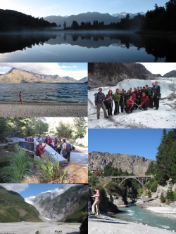 The geologically young landscapes of the South Island provide an enthralling natural laboratory for physical geographers to investigate a range of geomorphological processes and natural hazards, and to apply a variety of remote sensing techniques to characterise the environment. Taught by lecturers who are research-active in New Zealand; the primary objective of the trip is to equip students with the practical fieldwork skills that they need to undertake their geography dissertations.
The trip begins on the shores of Lake Wakatipu, with fieldwork focusing on measuring the form and processes of dynamic rivers, quantifying the carbon stored in ancient beech forests and understanding the impact of contemporary sediment cascades on flood risk. The second half of the trip is based at Mt Cook. Here, students learn to interpret satellite and aerial photography to map geomorphology, sample sediments that have been shaped by a range of terrestrial processes, and investigate contemporary glacial change. Many students undertake independent travel before or after the trip. Some head to the North Island to walk the Tongariro Crossing; others may visit Christchurch to witness the aftermath of the recent earthquake damage.
New York
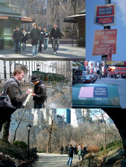 Our week-long United States field course to Manhattan, New York allows students to engage with a number of fundamental aspects of human geography. Staff lead group tours to neighbourhoods and sites around the city discussing themes of urban planning, cultural identity, economic geography, geopolitics, community activism, landscape architecture amongst other topics. They are then on hand to help guide and shape students’ own independent research which is undertaken in allocated slots throughout the week.
Over the years students have completed a range of projects with participation from city authorities, commercial enterprises, real estate firms, museum curators, and security personnel. Projects have examined practices of commemoration at Ground Zero, gentrification in Soho and the Lower East Side, land-use conflict in the Meat Packing District, emergency hurricane planning at Battery Park, the privatisation of public space in Times Square, as well as topics on race and racism in Chinatown, Greenwhich village and Harlem.
Crete
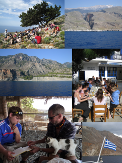 Crete is the largest of the Greek islands and lies roughly mid-way between the Greek mainland and the northern shores of Africa. It has been populated since c. 6000BC but it was during the Minoan Period (c. 3000 BC - 1100 BC) that the island exerted its strongest cultural influence in the Mediterranean. The island has is c. 200 km long and is home to three distinct mountain ranges; the highest peaks rise to over 2400 m above sea level. Its semi-arid climate, tectonic history (its lies on the margins of the Arifan and Eurasian plates), high relief and varied geology make Crete an ideal 'natural laboratory' to study the impacts of environmental change on landscape development and geomorphological processes. The staff who run the trip have extensive research experience of working on the island and/or in semi-arid environments. Many of the projects that students undertake have been developed from research projects published by Aberystwyth staff over the last 20 years or so.
The two-centre trip begins in Chora Sfakia where, over the first 3 days, a series of staff-led projects are undertaken. These include geomorphological mapping of Aradena Gorge, calculating historical flood magnitude in Illingas Gorge, and reconstructing the sequence of alluvial fan development. Day 4 of the trip involves a transfer (usually by ferry) to Palaeochora on the south-west tip of the island. This transfer day affords the opportunity to visit the world-famous Samaria Gorge. On the final two days of the trip students develop their own group project around one of three themes: Tsunamis, Rockall activity and river responses to tectonic uplift. The trip culminates with student presentations on the group project results and a meal in a local Greek Taverna. There is of course an opportunity to take a dip in the Mediterranean as well!
Dublin and the Wicklow Mountains
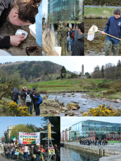 The capital city of the Republic of Ireland is a vibrant, modern city with a fascinating cultural, political, social and economic history. It is also a short drive from the picturesque and rural Glendalough Valley in the Wicklow Mountains National Park where the physical processes shaping the landscape intersect with the activities of modern and historical use by humans (tourism, agriculture, conservation and metal mining).
Based in the centre of Dublin, this trip explores themes that lie at the intersection of human and physical geography, including rescue geographies of post-industrial urban areas, rural land management and the place of nature in the city.
Students also practice using geomorphological, ecological and Quaternary science methods, and explore themes such as the geographies of Irish nationalism and identity. The cultural geographies of Dublin’s most famous export is also explored during a visit to the Guinness Storehouse – home of the black stuff!
Killarney, Southwest Ireland
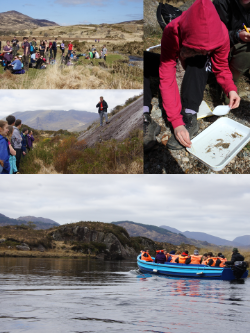 The Killarney field course provides an opportunity for students to gain skills in the design, application and presentation of environmental research in the renowned landscape of the Killarney National Park, SW Ireland.
The first orientation day involves a boat trip through the lakes followed by a 15 km hike, and an evening quiz session. Techniques for the analysis and mapping of glacial geomorphic features are then introduced in a class exercise in the Gap of Dunloe. On the third day, the class uses a variety of methods to measure river discharge and water quality, before examining the Bronze Age copper mines at the edge of the Lower Lake.
Biodiversity and carbon sequestration are the themes of the final class exercises, in which forest inventory and vegetation survey methods are used to estimate the carbon content of the native Irish oak and yew woods. Students then design and carry out their own projects, before presenting the results in an evening session on the last day of the course.