Fieldwork
Deployment
The team were deployed to Brandy Bay on James Ross Island in January 2011 by the RRV Ernest Shackleton. Logistical support was provided by the British Antarctic Survey. The scientists (Neil Glasser, Jonathan Carrivick, Bethan Davies) were joined by Alan Hill, a field safety expert. Equipment was unloaded by the Tula, a shallow-draft landing vessel. En route we stopped at Signy Island, where we saw several colonies of Adélie and Chinstrap penguins, fur seals and elephant seals.
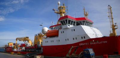
Figure 9. The RRS Ernest Shackleton at Port Stanley in the Falkland Islands: the start of the adventure
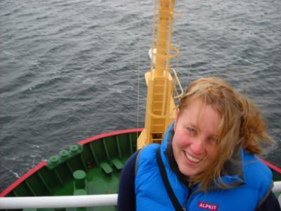
Figure 10. Bethan on top of the Bridge, RRS Ernest Shackleton
Campsite
The team camped near Monolith Lake, which provided (on warm days, at least) a source of fresh water. On cold days, when the lake was frozen, the team melted snow for drinking water. Sleeping quarters were two One Planet pyramid tents, with large vestibules that were useful for storing equipment. We also had a large dome tent for cooking and working in, a toilet tent and a storage tent. Down jackets provided by Alpkit helped keep us nice and warm! The BAS pyramid tents proved to be very strong and durable, capable of standing up to the worst of the Antarctic weather. The same cannot be said for our mess tent, however!
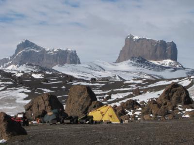
Figure 11. Base camp, looking east towards Lookalike Peaks. Note the large hyaloclastite boulders surrounding the campsite.

Figure 12. The team. From left: Bethan Davies, Alan Hill, Neil Glasser, Jonathan Carrivick. Photograph courtesy of Jonathan Carrivick.
Fieldwork
Fieldwork was organised around several core themes. The first was to understand the Last Glacial Maximum glaciation in the area. To this end, we took many cosmogenic nuclide samples from the scattered granite erratics, undertook stone counts and shape-roundness counts to understand changing provenance and debris transport pathways, and mapped and described in detail sediments and landforms. Cosmogenic nuclide samples were taken with a hammer and chisel, which could take many hours! Mapping of landforms and their combination in a GIS with published data allowed the creation of a detailed geomorphological map.
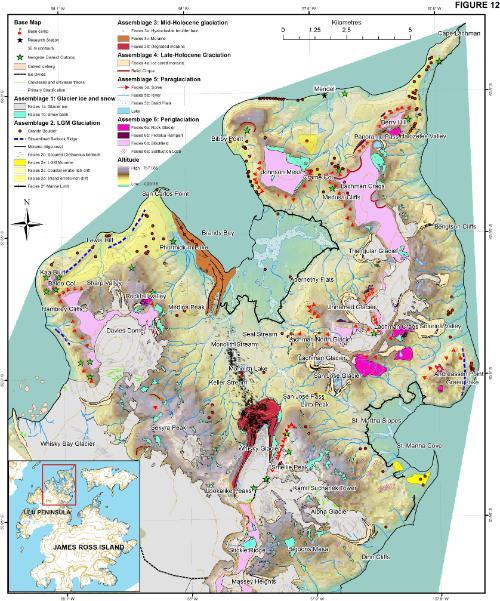
Figure 13.Geomorphological map created using a Geographical Information System from remotely sensed images and fieldwork. Note the large moraine in Brandy Bay and the boulder train stretching from Whisky Glacier to Brandy Bay. Note also the large ice-cored moraines dating from Late Holocene readvances of the small cirque glaciers.
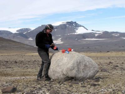
Figure 14. Alan Hill samples a large granite boulder for cosmogenic nuclide dating. This boulder was probably emplaced around 18 ka BP, during the Last Glacial Maximum on the Antarctic Peninsula, when glaciers from Trinity Peninsula overwhelmed James Ross Island.
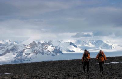
Figure 15. Walking across Hambrey Mesa in search of granite erratics.
Figure 16. Stone shape-roundness and stone lithology counts. 50 stones are measured and identified in each sample.
The second theme was the Holocene dynamics of the glaciers on the Ulu Peninsula. Is the recent rapid retreat part of long-term thinning, or is it entirely out of context throughout the entire Holocene (the last 10,000 years)? It is therefore important to reconstruct the glaciation of the north-eastern Antarctic Peninsula over multiple timescales. Methodologies were similar for this theme, although attention was focussed on a boulder train (Figures 7, 11 and 17) leading from Whisky Glacier to Brandy Bay, and a moraine in Brandy Bay (Figure 13). Cosmogenic nuclide samples, in conjunction with sediment-landform studies, will tell us how and when these landforms developed, and whether they were synchronous with a Mid-Holocene collapse of the Prince Gustav Ice Shelf (approximately 5000 years ago).
Figure 17. View from Whisky Glacier moraine to Brandy Bay. Note the train of hyaloclastite boulders extending from Whisky Glacier towards the Antarctic Peninsula. Cosmogenic nuclide dating will determine when this readvance took place.
The third theme was the Late Holocene behaviour of small land-terminating glaciers on James Ross Island. The mass balance of these glaciers is determined directly by climate; too much warmth and too little snow, and the glaciers will recede. The large ice-cored moraines (Figures 5, 13 and 18) surrounding these glaciers provide clues as to their former extent, character and behaviour. Cosmogenic nuclide dating of these moraines, combined with detailed structural analysis of the glaciers and the moraines, will tell us when the glaciers reached their Late Holocene maximum.
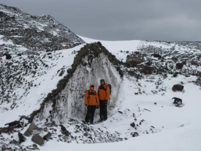
Figure 18. Scar showing glacier ice in an ice-cored moraine. Note the thin cover of debris.
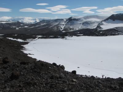
Figure 19. The small "Unnamed Glacier"; small and cold, with few crevasses but with prominent ice-cored moraines. Note the large basalt boulders on the moraines. In the distance, you can see the flat-topped Mesas, with lentincular clouds above them. In the far distance you can see Trinity Peninsula.
Finally, it is important to document the most recent changes in the glacier extent and behaviour on James Ross Island. This was achieved in two ways. Firstly, glacier surface elevation was measured accurately using a Differential GPS (Figures 19 and 20).
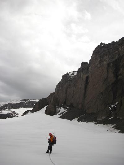
Figure 20. Surveying Triangular Glacier with a Differential GPS.
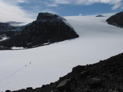
Figure 21. Surveying "Unnamed Glacier": one of several transects with a Differential GPS. This data can be compared to digital elevation models made from satellite images, so elevation change can be considered over multiple timescales.
Another way in which you can monitor glacier change is by conducting glacier inventories from satellite images. Figure 21 shows the glaciers of Trinity Peninsula, Vega Island, Snow Hill Island and James Ross Island. They have been remotely mapped in the years 1988 (pre-ice shelf collapse), 1997, 2001 and 2009. It is clear that almost all of the glaciers have been retreating throughout this period, with the fastest rates of recession amongst those glaciers that have changed from ice-shelf tributary to tidewater glaciers.
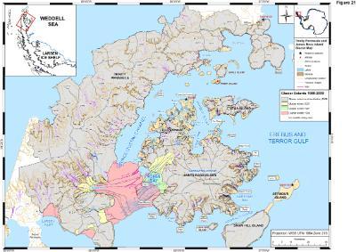
Figure 22. Glacier inventory of the northern Antarctic Peninsula. Note the collapse of the Prince Gustav Ice Shelf in 1995, and the glacier recession in almost all the tidewater and land-terminating glaciers.
More results from all of this work will be posted on this website once it has been completed and published.
Fieldwork: February 2012
In February 2012, Bethan Davies, Mike Hambrey and John Smellie will be heading back to James Ross Island to collect more samples, undertake more cosmogenic nuclide dating, and to continue their work on mid- and Late-Holocene glacier change. This time, they will be logistically supported by the Royal Navy.