Spatial Intelligence System (SIS) for malaria vector control
Spatial Intelligence System (SIS) for malaria control
The SIS in an initiative, co-developed with multiple organisations notably including the Zanzibar Malaria Elimination Programme, that aims to reduce malaria transmission by providing 'spatial intelligence' through the use of smartphone technology and drones. The project takes place in Zanzibar who are on the cusp of eliminating malaria from their islands - but to achieve these ambitious goals they need to look towards innovative interventions like the use of drones to find the water bodies that malaria mosquitoes use to breed and lay eggs.
Collaboration
This work was a collaborative endeavour sharing ideas and learning lessions from data scientists, economists, epidemiologies, entomologists, public health practicioneers, social scientists and software developers: working together to achieve a common goal.
Alongside Aberystwyth University, this program was co-produced with the Zanzibar Malaria Elimination Program, the London School of Hygiene and Tropical Medicine, the Liverpool School of Tropical Medicine, the Tanzanian Flying Labs, Zzapp Malaria, the Pan African Mosqutio Control Association and the Innovative Vector Control Consortium.
Led by Dr Andy Hardy at Aberystwyth University this program was co-produced in collaboration with the Zanzibar Malaria Elimination Programme, Liverpool School of Tropical Medicine, London School of Hygiene and Tropical Medicine, the Tanzanian Flying Labs, Zzapp Malaria (recent winners of the prestigeous IBM Watson AI XPRIZE) and the Pan-African Mosquito Control Association (PAMCA), funded by the Bill and Melinda Gates Foundation through a grant managed by the Innovative Vector Control Consortium (IVCC).
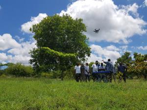
The goal of this research programme is to evaluate the use of drones for supporting malarial mosqutio larval control. This work showed that the drone-smartphone system, assited by a novel and user-friendly Technology Assisted Digitizing (TAD) mapping approach, vastly improved efforts to map potential mosqutio breeding sites. Moreover, this approach proved to be cheaper overtime than conventional ground-based mapping. Therefore, the SIS system represents an important investment in the battle against malaria.
Dr Andy Hardy and his collaborators are looking to scale up the SIS approach to other areas burdened by malaria.
Beyond drones
Dr Andy Hardy and colleagues are also developing novel approaches for extracting Spatial Intelligence for tackling vector borne diseases using Satellite Earth Observation (EO) and hydrological terrain analysis.
This covers a range of activities inlcuding wetland mapping using radar (read more here) and optical EO imagery, machine learning modelling (see example here) and hydrological terrain analysis.
Check out the team's free to use Tropical Wetland mapping tool: TropWet.
References
Improved Use of Drone Imagery for Malaria Vector Control through Technology-Assisted Digitizing (TAD) Hardy, A., Oakes, G., Hassan, J. & Yussuf, Y., 11 Jan 2022, In: Remote Sensing.
Conditional trust: Community perceptions of drone use in malaria control in Zanzibar Hardy, A., Proctor, M., MacCallum, C., Shawe, J., Abdalla, S., Ali, R., Abdalla, S., Oakes, G., Rosu, L. & Worrall, E., Jan 2022, In: Technology in Society.
Geographically extensive larval surveys reveal an unexpected scarcity of primary vector mosquitoes in a region of persistent malaria transmission in western Zambia Cross, D., Thomas, C., McKeown, N., Siaziyu, V., Healey, A., Willis, T., Singini, D., Liywalii, F., Silumesii, A., Sakala, J., Smith, M., Macklin, M., Hardy, A. & Shaw, P., 01 Feb 2021, In: Parasites & Vectors. 14, 14 p., 91.
Incorporating hydrology into climate suitability models changes projections of malaria transmission in Africa Smith, M. W., Willis, T., Alfieri, L., James, W. H. M., Trigg, M. A., Yamazaki, D., Hardy, A. J., Bisselink, B., De Roo, A., Macklin, M. G. & Thomas, C. J., 28 Aug 2020, (E-pub ahead of print) In: Nature Communications. 11, 1, p. 1-9 9 p., 4353.
Tropical Wetland (TropWet) Mapping Tool: The Automatic Detection of Open and Vegetated Waterbodies in Google Earth Engine for Tropical Wetlands Hardy, A., Oakes, G. & Ettritch, G., 07 Apr 2020, In: Remote Sensing. 12, 7, 24 p., 1182.
Automatic Detection of Open and Vegetated Water Bodies Using Sentinel 1 to Map African Malaria Vector Mosquito Breeding Habitats Hardy, A., Ettritch, G., Cross, D., Bunting, P., Liywalii, F., Sakala, J., Silumesii, A., Singini, D., Smith, M. W., Willis, T. & Thomas, C., 12 Mar 2019, In: Remote Sensing. 11, 5, p. 1-25 25 p., 593.
Enhancing digital elevation models for hydraulic modelling using flood frequency detection Ettritch, G., Hardy, A., Bojang, L., Cross, D., Bunting, P. & Brewer, P., 30 Nov 2018, In: Remote Sensing of Environment. 217, p. 506-522 17 p.
Using low-cost drones to map malaria vector habitats Hardy, A., Makame, M., Cross, D., Majambare, S. & Msellem, M., 14 Jan 2017, In: Parasites & Vectors. 10, 29.
Mapping hotspots of malaria transmission from pre-existing hydrology, geology and geomorphology data in the pre-elimination context of Zanzibar, United Republic of Tanzania Hardy, A., Mageni, Z., Dongus, S., Killeen, G., Macklin, M. G., Majambare, S., Ali, A., Msellem, M., Al-mafazy, A., Smith, M. & Thomas, C., 22 Jan 2015, In: Parasites & Vectors. 8, 1, 41.
Habitat hydrology and geomorphology control the distribution of malaria vector larvae in rural Africa. Hardy, A. J., Gamarra, J. G. P., Cross, D. E., Macklin, M. G., Smith, M. W., Kihonda, J., Killeen, G. F., Ling'ala, G. N. & Thomas, C. J., 03 Dec 2013, In: PLoS One. 8, 12, p. n/a 13 p., e81931.